UPDATE - 4 p.m. Thursday, Dec. 2:
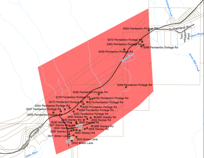
An evacuation order for 40 properties in Birken was rescinded on Thursday afternoon.
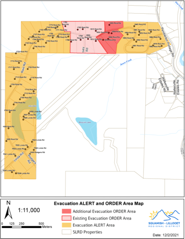
Two evacuation orders for properties on Reid Road remain in place as of Thursday afternoon. One applies to eight properties impacted by a washout early Wednesday morning, while a subsequent order was issued late Wednesday night for . Dozens of additional properties in the area remain under evacuation alert.

on Thursday afternoon, Dec. 2, for three low-lying properties on Collins Road and Urdal Road in Electoral Area C.
The alert comes in response to the flood watch issued for the Sea to Sky and Lower Fraser regions by the BC River Forecast Centre, due to heavy precipitation from yesterday's atmospheric river event.
Though skies have cleared for the time being, tere is potential for the current high water levels observed in the Arn Canal to elevate further before this weather system passes, according to the SLRD.
___
Wednesday, Dec. 1 at 5 p.m.:
A series of evacuation orders and alerts remain in place for parts of the Squamish-Lillooet Regional District (SLRD) Wednesday afternoon.
The first order was issued late Tuesday night, Nov. 30 for , near the Gates River in the SLRD’s Area C. The order was triggered by "immediate danger to life safety” posed by a landslide hazard at Neff Creek, the regional district said on its website.
The road from Birken to D’Arcy through the evacuation order area is also . Two members from Pemberton RCMP were assisted by members of the Birken Volunteer Fire Department to advise residents of the order, while B.C. Ministry of Transportation staff are on-site handling traffic control.
All properties within the evacuation order have since been notified, and most have left the area. Three people chose to stay behind, according to an SLRD spokesperson.
At around 4 a.m. on Wednesday, Dec. 1, —about 25 kilometres southwest of Birken—subsequently prompted a tactical, or no-notice, evacuation of by Pemberton Fire Rescue and RCMP, due to “immediate life safety concerns.”
Asked about the size of washout and whether any structures have been affected, SLRD staff said, “A geotechnical assessment is underway. We do not know scope of size yet.”
Reid Road remains inaccessible for the time being.
An evacuation alert was also issued for a total of 54 properties in the Reid Road area at around 3 p.m. Wednesday “due to the risk of a mass flow event.” Residents are asked to prepare to leave their properties, should it be found necessary.
A is currently in place for 11 properties in Pemberton, near Vine Road and Highway 99, as of Wednesday afternoon. Those residents are asked to prepare to leave as heavy precipitation and snowmelt are expected to make their way downstream and raise water levels in the Lillooet River by Thursday, Dec. 2.
B.C.’s River Forecast Centre has also issued a for the area. This means river levels have exceeded or will exceed bankfull imminently, "and that flooding of areas adjacent to the rivers affected will result." According to the Pemberton Valley Dyking District (PVDD), large pumps have been set up at the Arn Canal outlet and the North Arm Channel outlet as a precaution. “These pumps are only for the off handed chance that the Lillooet River rises and then ability for the area to drain by gravity alone is impeded,” the PVDD explained in a .
The Village of Pemberton also closed One Mile Lake Park Boardwalk, Trail and Dog Beach on Wednesday, due to high water. The Pemberton Friendship Trail is also closed temporarily due to pooling water.
Residents under evacuation alert are advised to:
- Locate all family members and designate a meeting area outside the evacuation area, should an Evacuation Order be called while separated.
- Pack essential items such as government-issued ID, medications, eyeglasses, valuable papers (e.g. insurance, credit, and mortgage information), immediate care needs for dependents and, if time and space permits, keepsakes for quick departure.
- Prepare to move disabled persons, children and/or neighbours, if assistance is needed.
- Prepare to take pets with you and move livestock to a safe area (if possible).
- Arrange transportation and accommodations for all your household members, if possible.
- Fill the gas tanks of personal vehicles. If transportation assistance is needed, call the SLRD’s Emergency Operations Centre at (604) 894 6371.
- Wait for an evacuation order to be issued before evacuating.
Residents under evacuation order must leave the area immediately. They are also asked to:
- Evacuate south on Pemberton Portage Rd toward the Village of Pemberton.
- Call (604) 894-6371 if in need of transportation assistance from the area,
- Shut off all gas and electrical appliances, other than refrigerators and freezers.
- Close all windows and doors.
- Close gates (latch) but do not lock.
- Gather your family and, if you have room, take a neighbour or someone needing transportation. Do not use more vehicles then you have to.
- Take critical items (medicine, purse, wallet, and keys) only if they are immediately available. Take pets in pet kennels or on leash.
- Not use the telephone unless you need emergency service.
Evacuees requiring emergency assistance can call 1-855-736-2121 to register. Emergency Accommodation for evacuees is currently available at the Hilton in Whistler Village.
As of Wednesday morning, a total of 16 people under evacuation order had checked into rooms at the Hilton Whistler. The emergency accommodation is coordinated by Emergency Management BC and funded by the Red Cross.
Further info will be posted in notices to the and through the SLRD Alert Messaging service. Residents can to receive emergency notifications via email, text messages, and voicemail.
HIGH TEMPERATURES, SNOWMELT POSE ADDED RISK
The atmospheric rivers dumping rain on B.C. have also raised alpine temperatures to record levels across many ranges.
Environment Canada warning preparedness meteorologist Armel Castellan said that’s expected to trigger widespread snowmelt, further contributing to already flooded rivers.
Dave Campbell with the B.C. River Forecast Centre says snowmelt has already added another 50 to 60 millimetres of rainfall-equivalent melt water.
“Through the South Coast is really where we've seen quite significant rapid rising rivers around the Howe Sound and Fraser Valley areas,” he said.
On Wednesday, valley temperatures reached a high of 8.5 degrees C in Whistler and 7.9 degrees C in Pemberton. That set a record for the warmest Dec. 1 on record for both municipalities. Whistler's average high temperature for Dec. 1 is 0.7 degrees C. The freezing level in Whistler hovered at around 2000 metres for most of the day Wednesday, according to snow-forecast.com.
Conditions also broke records for the wettest Dec. 1 on record. A total of 34.9 mm of precipitation fell over Whistler on Tuesday, followed by another 45.6 mm on Wednesday. Pemberton logged 26.9mm of precipitation on Tuesday, and 51.6 mm on Wednesday.
- With files from Stefan Labbe


